WGM2012 Earth gravity model (BGI)

General information
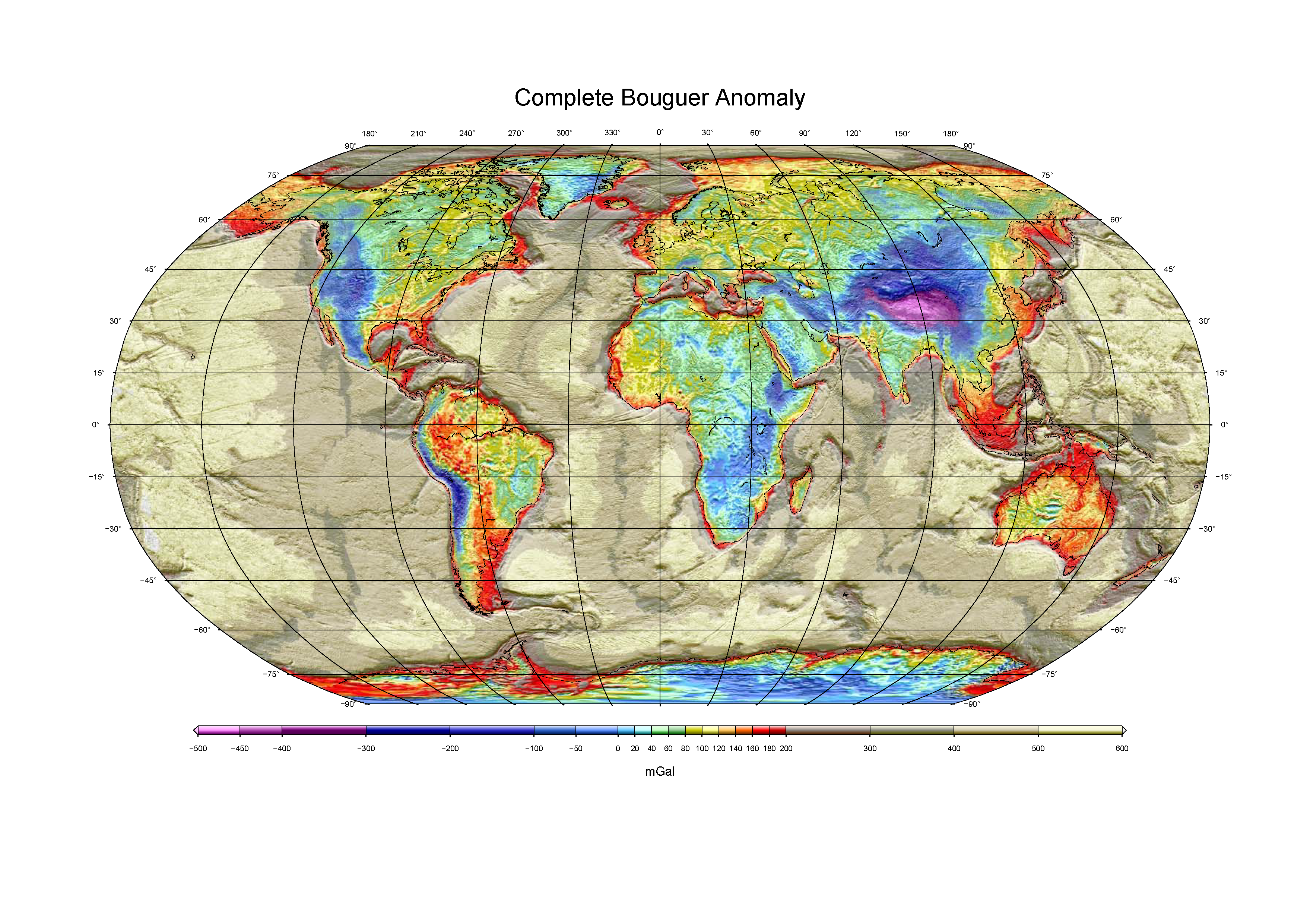
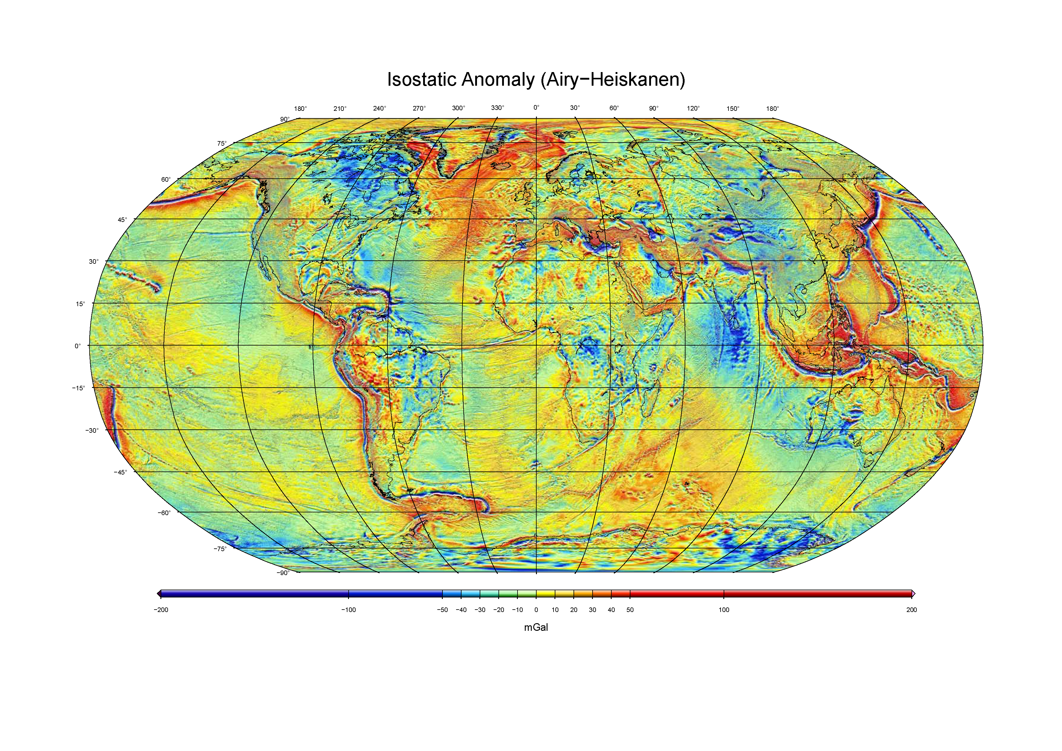
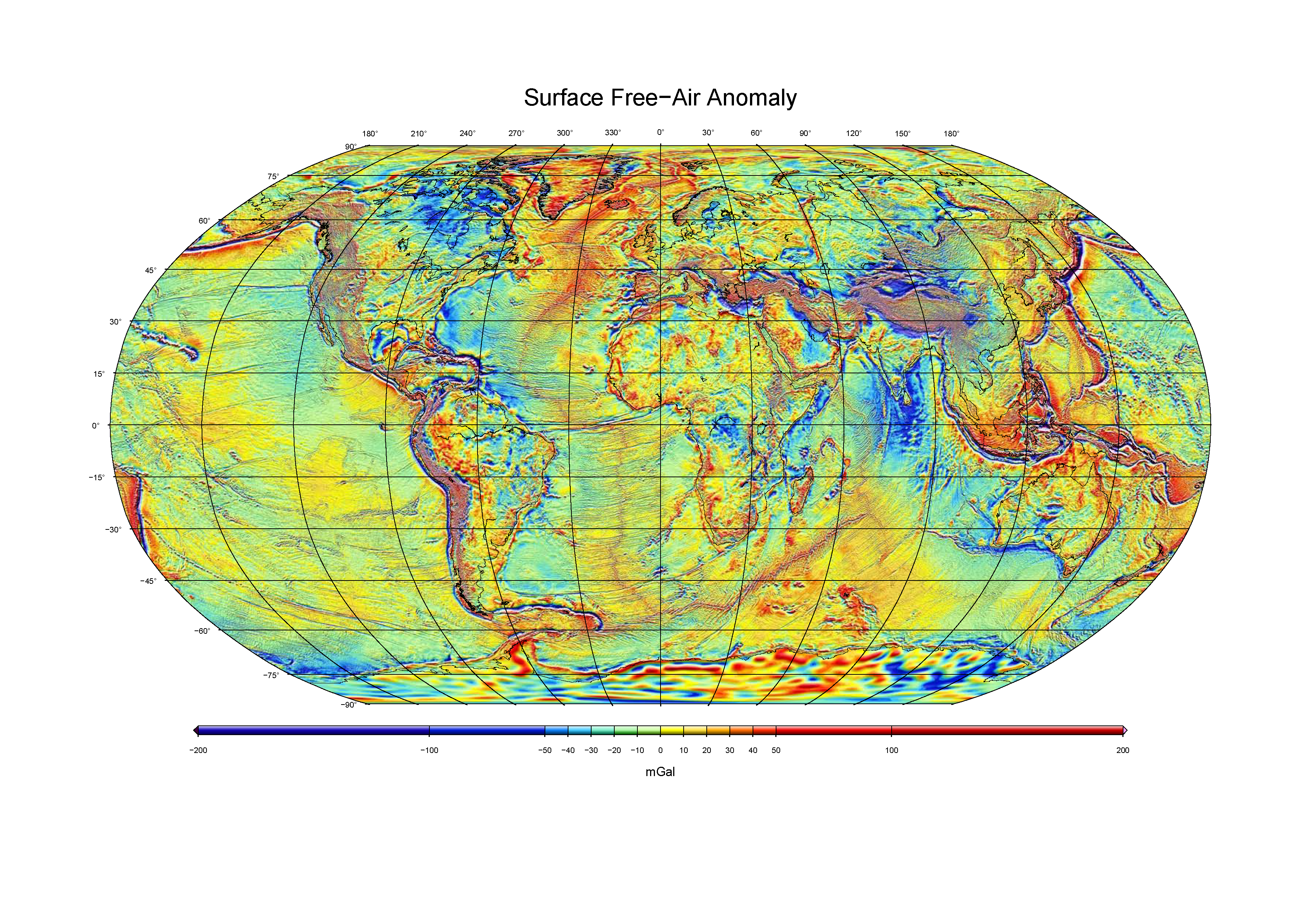
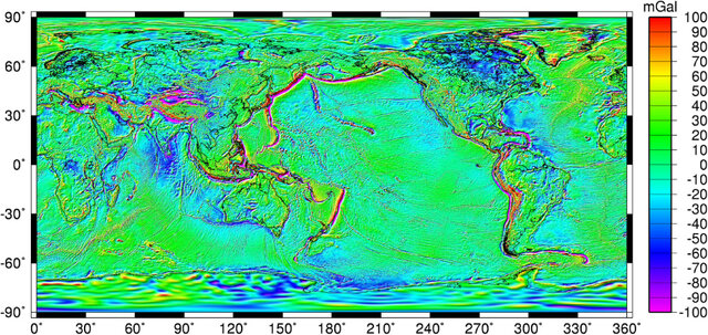
Summary : WGM2012 is the first release of a high resolution grids and maps of the Earth’s gravity anomalies (complete Bouguer, isostatic and surface free-air), computed at global scale in spherical geometry. It has been realized by the Bureau Gravimétrique International (BGI) in the frame of collaborations with international organizations such as Commission for the Geological Map of the World (CGMW), UNESCO, International Association of Geodesy (IAG), International Union of Geodesy and Geophysics (IUGG), International Union of Geological Sciences (IUGS) and with various scientific institutions.
WGM2012 gravity anomalies are derived from the available Earth global gravity models EGM2008 and DTU10 and include 1’x1′ resolution terrain corrections derived from ETOPO1 model that consider the contribution of most surface masses (atmosphere, land, oceans, inland seas, lakes, ice caps and ice shelves). These products have been computed by means of a spherical harmonic approach using theoretical developments carried out to achieve accurate computations at global scale (Balmino, G., Vales, N., Bonvalot, S. and Briais, A., 2011. Spherical harmonic modeling to ultra-high degree of Bouguer and isostatic anomalies. Journal of Geodesy. DOI 10.1007/s00190-011-0533-4).
How to cite : Bonvalot, S., Briais, A., Kuhn, M., Peyrefitte, A., Vales, N., Biancale, R., Gabalda, G., Moreaux, G., Reinquin, F. & Sarrailh, M. (2012). Global grids : World Gravity Map (WGM2012). Bureau Gravimetrique International. https://doi.org/10.18168/bgi.23
Additional information :
- WGM2012 reference explanatory leaflet : WGM_2012_explanatory_leaflet.pdf 14,93 MB
- WGM2012 methodological paper : Balmino, G., Vales, N., Bonvalot, S. and Briais, A., 2011. Spherical harmonic modeling to ultra-high degree of Bouguer and isostatic anomalies. Journal of Geodesy. DOI 10.1007/s00190-011-0533-4. 2011_Balmino_JOGEOD.pdf 2,85 MB
- WGM2012 maps (1:50 000 000) : Commision for the Geological Map of the World (CGMW)
Disclaimer : WGM2012 digital products are provided for academic purposes. No warranty is given on the accuracy of the data and models. By using these products, users acknowledge that BGI is not responsible for any consequence of the use of the data or models.
Available grids (2’x2′ resolution)
- Complete spherical Bouguer anomaly
- Complete spherical Isostatic anomaly (Airy-Heiskanen, Tc=30km)
- Surface free-air anomaly (Molodenski)
- ETOPO1-derived gravity disturbances of surfaces masses
- ETOPO1 topography
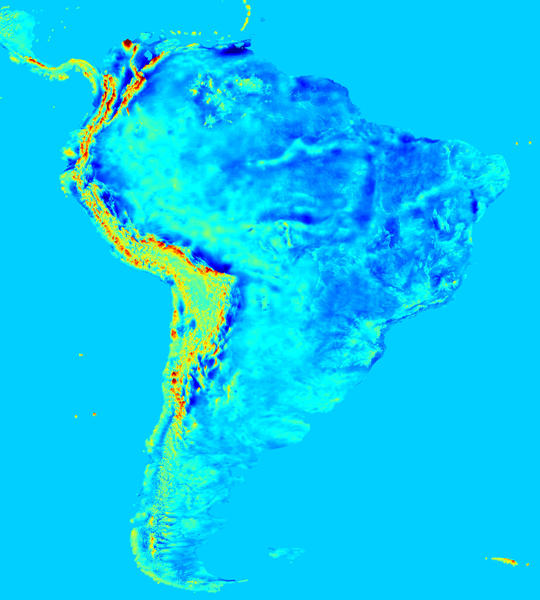
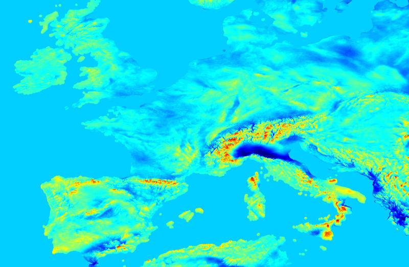
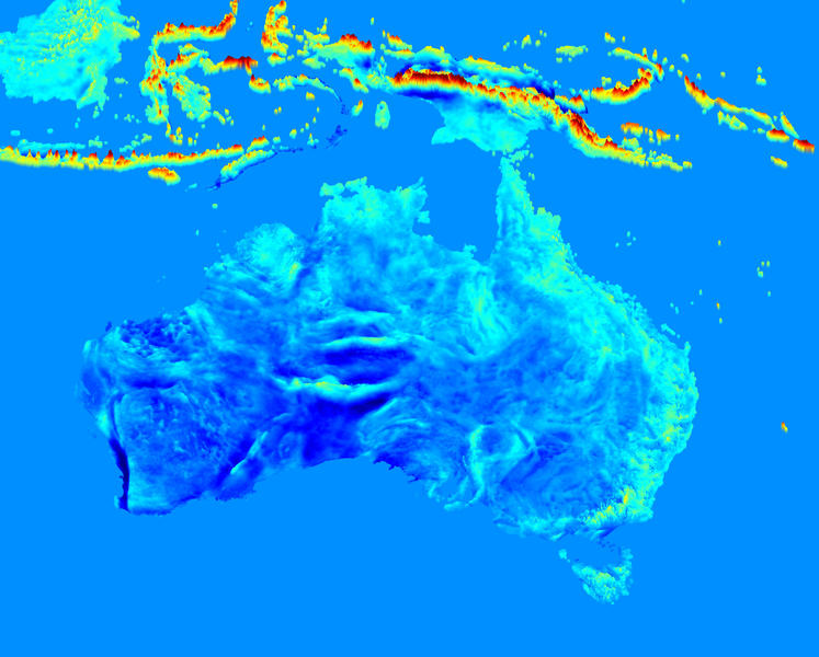
GGMplus2023 Earth gravity model (Curtin Univ.)
General information
Summary : GGMplus (Global Gravity Model plus) is a composite of GRACE and GOCE satellite gravity, EGM2008 and short-wavelength topographic gravity effects at about 200 m resolution for all terrestrial and near-coastal areas of the Earth between ±60° latitude. The GGMplus gravity model is the result of a research initiative of Curtin University (Perth, Western Australia) and Technical University of Munich (Germany).
The GGMplus model encompasses gridded estimates of (i) gravity accelerations, (ii) gravity disturbances, (iii) quasigeoid undulations, and (iv) deflection of the vertical components. The data is distributed as a series of 5° x 5° tiles at a grid resolution of 0.002 degrees (7.2 arc-seconds). Short-wavelength features less than about 10 km in the GGMplus data are not derived from observations but were computed with gravity forward modelling from 7.5 arc-second (~200 m) SRTM topography by assuming a constant density of 2670 kg m-3. These short-wavelength features are not amenable to standard ‘mass difference’ interpretations. GGMplus gravity data is available over land and near-coastal areas with near-global coverage, within 60 degree North and South latitude.
How to cite : Hirt, C., S.J. Claessens, T. Fecher, M. Kuhn, R. Pail, M. Rexer (2013) New ultrahigh-resolution picture of Earth’s gravity field, Geophysical Research Letters, Vol40(16), 4279-4283,doi: 10.1002/grl.50838. BGI_hirt2013_ultrahighres_gravity.pdf 675,74 kB
GGMplus data access
- GGMplus data can be accessed via the GGMplus download page :
http://ddfe.curtin.edu.au/gravitymodels/GGMplus/ - Information on the data formats can be found at : http://ddfe.curtin.edu.au/gravitymodels/GGMplus/GGMplus_readme.dat
- For more general information :
https://ddfe.curtin.edu.au/gravitymodels/GGMplus/hirt2013_ultrahighres_gravity.pdf
EGM2008 Earth gravity model (NGA)
General information
Summary
The official Earth Gravitational Model EGM2008 has been publicly released by the National Geospatial-Intelligence Agency (NGA) EGM Development Team (N. K. Pavlis, S. A. Holmes, S. C. Kenyon and J. K. Factor. “An Earth Gravitational Model to Degree 2160: EGM2008”. EGU General Assembly 2008, Vienna, Austria, April 13-18, 2008). This gravitational model is complete to spherical harmonic degree and order 2159, and contains additional coefficients extending to degree 2190 and order 2159. For more information, visit the EGM2008 webpage at the following link (NGA website) : https://earth-info.nga.mil/
References
- Pavlis, N. K., S. A. Holmes, S. C. Kenyon, and J. K. Factor (2012), The development and evaluation of the EarthGravitational Model 2008 (EGM2008),J. Geophys. Res.,117, B04406, https://agupubs.onlinelibrary.wiley.com/doi/10.1029/2011JB008916
- N. K. Pavlis, S. A. Holmes, S. C. Kenyon, J. K. Factor. An Earth Gravitational Model to Degree 2160: EGM2008. EGU General Assembly 2008, Vienna, Austria, April 13-18, 2008.
- Fullea, J., Fernandez, M., Zeyen, H., 2008. “FA2BOUG – A FORTRAN 90 code to compute Bouguer gravity anomalies from gridded free-air anomalies: Application to the Atlantic-Mediterranean transition zone”.Computers & Geosciences, Volume 34, Issue 12 (December 2008) pp. 1665-1681, ISSN:0098-3004. DOI: 10.1016/j.cageo.2008.02.018
EGM2008 data access
EGM2008 global model
For more information and full data access to EGM2008 Earth gravity model, visit the EGM2008 webpage at the following link (NGA website) : https://earth-info.nga.mil/
EGM2008 derived regional freeair and Bouguer anomaly
Regional Free-air and Bouguer gravity anomaly derived from the EGM2008 are accessible hereafter. Free-air and Bouguer gravity anomaly grids (averaged over 2,5 arc-minute by 2,5 arc-minute) were computed at BGI from the EGM2008 spherical harmonic coefficients (Pavlis et al., 2008). The Bouguer corrections computed at regional scales are obtained using the FA2BOUG code developed by Fullea et al. (2008). The topographic correction is applied up to a distance of 167 km using the 1 arc-minute by 1 arc-minute ETOPO1 Digital Elevation Model. Density reduction for Bouguer anomaly : 2,67.
- Fullea, J., Fernandez, M., Zeyen, H., 2008. “FA2BOUG – A FORTRAN 90 code to compute Bouguer gravity anomalies from gridded free-air anomalies: Application to the Atlantic-Mediterranean transition zone”.Computers & Geosciences, Volume 34, Issue 12 (December 2008) pp. 1665-1681, ISSN:0098-3004. DOI: 10.1016/j.cageo.2008.02.018