Pan-Alpine Gravity database
(Zahorec et al., 2021)
Summary
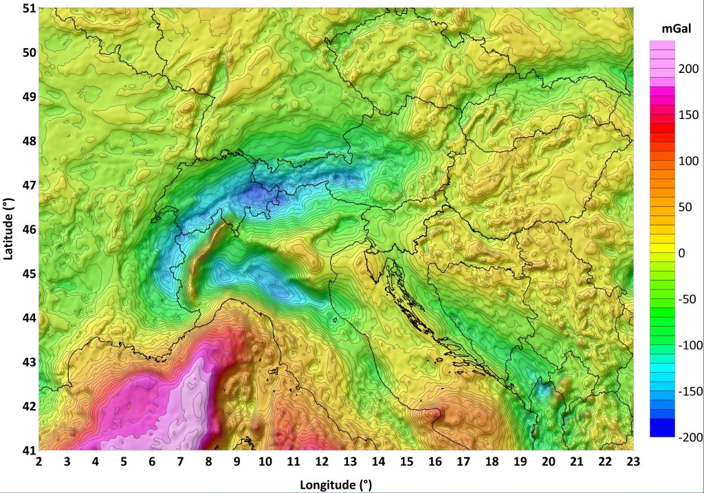
The AlpArray Gravity Research Group (AAGRG), as part of the European AlpArray program, focuses on the compilation of a homogeneous surface-based gravity data set across the Alpine area. In 2017 10 European countries in the Alpine realm agreed to contribute with gravity data for a new compilation of the Alpine gravity field in an area spanning from 2 to 23∘ E and from 41 to 51∘ N. This compilation relies on existing national gravity databases and, for the Ligurian and the Adriatic seas, on shipborne data of the Service Hydrographique et Océanographique de la Marine and of the Bureau Gravimétrique International. Furthermore, for the Ivrea zone in the Western Alps, recently acquired data were added to the database. This first pan-Alpine gravity data map is homogeneous regarding input data sets, applied methods and all corrections, as well as reference frames.
Here, the AAGRG presents the data set of the recalculated gravity fields on a 4 km × 4 km grid for public release and a 2 km × 2 km grid for special request. The final products also include calculated values for mass and bathymetry corrections of the measured gravity at each grid point, as well as height. This allows users to use later customized densities for their own calculations of mass corrections. Correction densities used are 2670 kg m−3 for landmasses, 1030 kg m−3 for water masses above the ellipsoid and −1640 kg m−3 for those below the ellipsoid and 1000 kg m−3 for lake water masses. The correction radius was set to the Hayford zone O2 (167 km). The new Bouguer anomaly is station completed (CBA) and compiled according to the most modern criteria and reference frames (both positioning and gravity), including atmospheric corrections. Special emphasis was put on the gravity effect of the numerous lakes in the study area, which can have an effect of up to 5 mGal for gravity stations located at shorelines with steep slopes, e.g., for the rather deep reservoirs in the Alps.
How to cite
- Zahorec, P., Papčo, J., Pašteka, R., Bielik, M., Bonvalot, S., Braitenberg, C., Ebbing, J., Gabriel, G., Gosar, A., Grand, A., Götze, H.-J., Hetényi, G., Holzrichter, N., Kissling, E., Marti, U., Meurers, B., Mrlina, J., Nogová, E., Pastorutti, A., Salaun, C., Scarponi, M., Sebera, J., Seoane, L., Skiba, P., Szűcs, E., and Varga, M.: The first pan-Alpine surface-gravity database, a modern compilation that crosses frontiers, Earth Syst. Sci. Data, 13, 2165–2209, https://doi.org/10.5194/essd-13-2165-2021, 2021
Data access
The data are published with the
DOI https://doi.org/10.5880/fidgeo.2020.045 (Zahorec et al., 2021) via GFZ Data Services
Vietnam : Gravity, Quasigeoid and Lithospheric models
(Vu et al., 2019, 2020, 2021)
Summary
We provide here a dataset containing gravity anomaly grids and maps (i.e., Free-air, complete Bouguer and Isostatic Airy-Heiskanen) determined for Vietnam and its surrounding areas at BGI (see references below). These products computed at 1′ resolution were obtained from the combination of heterogeneous data including 29,121 cleaned-up terrestrial gravity points, global gravity models, and high-resolution topographic and bathymetric data.


How to cite
- Vu D.T., Bruinsma S., Bonvalot S., Bui L.K., Balmino G. (2021). Determination of the geopotential value on the permanent GNSS stations in Vietnam based on the Geodetic Boundary Value Problem approach. Geophysical Journal International, 226, 2, August 2021, Pages 1206–1219, https://doi.org/10.1093/gji/ggab166
- Vu D.T., Bonvalot S., Bruinsma S., Bui L.K. (2021). A local lithospheric structure model for Vietnam derived from a high-resolution gravimetric geoid. Earth Planets & Space, 73:92, https://doi.org/10.1186/s40623-021-01415-2
- Vu D.T., Bruinsma S., Bonvalot S., Remy D., Vergos G. (2020). A quasigeoid derived transformation model accounting for land subsidence in the Mekong Delta towards height system unification in Vietnam. Remote Sensing, 12(5), 817; https://doi.org/10.3390/rs12050817
- Vu D.T., Bruinsma S., Bonvalot S. (2019). A high resolution gravimetric geoid model for Vietnam. Earth, Planets and Space. 71:65. https://doi.org/10.1186/s40623-019-1045-3
- Vu D. T. (2020). Height system unification and estimation of the lithospheric structure beneath Vietnam through high-resolution gravity field and quasigeoid modeling. PhD dissertation. Université Toulouse III – Paul Sabatier.
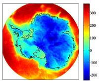
Antarctica : Bouguer anomaly and crustal thickness model
(Llubes et al. 2018)
Summary
We provide here a global map of Antarctic crustal thickness computed from space gravity observations as presented in Llubes et al. (2018). The DIR5 gravity field model, built from GOCE and GRACE gravimetric data, is inverted with the Parker–Oldenburg iterative algorithm. The BEDMAP products are used to estimate the gravity effect of the ice and the rocky surface. Finally, we compute a model in which the crust–mantle density contrast is adjusted to fit the Moho depth from the CRUST1.0 model. In East Antarctica, the resulting density contrast clearly shows higher values than in West Antarctica


Available grids
(Grids are available at resolutions of 5km and GOCE resolution 77km)
- Bouguer anomalies estimated using free air anomalies of DIR5 gravity model (Bruinsma et al. 2014)
- Crustal thickness model (Llubes et al., 2018)
- Terrain gravity effects of ice, sea and surface rock derived from BEDMAP products from (Fretwell et al. 2013) is also provided
Contacts : lucia.seoane@get.omp.eu and muriel.llubes@get.omp.eu
How to cite
- Llubes, M., Seoane, L., Bruinsma, S., and Rémy, F. (2018) : Crustal thickness of Antarctica estimated using data from gravimetric satellites, Solid Earth, 9, 457–467, https://doi.org/10.5194/se-9-457-2018
References
- Bruinsma, S. L., Förste, C., Abrikosov, O., Lemoine, J.-M., Marty, J.-C., Mulet, S., Rio, M.-H. and Bonvalot, S.: ESA’s satellite-only gravity field model via the direct approach based on all GOCE data, Geophys. Res. Lett., 41(21), 7508–7514, doi:10.1002/2014GL062045, 2014.
- Llubes, M., Seoane L., Bruinsma S. Remy F. (2018) . Crustal Thickness of Antarctica estimated using data from gravimetric satellites. Solid Earth, 9, 457-467, DOI: doi.org/10.5194/se-9-457-2018
- Fretwell, P., et al. (2013). Bedmap2: improved ice bed, surface and thickness datasets for Antarctica, The Cryosphere, 7(1), 375–393, doi:10.5194/tc-7-375-2013.