BGI uses own processing tools and software developed and maintained by BGI and associated partners as well as the commercial software for the evaluation of relative and absolute gravity surveys and for gravity data processing.
BGI home-made software include a series of routines and interactive interfaces for checking the reliability of the gravity data acquisition and corrections, the reference systems and standards used and the compatibility and consistency of incoming datasets into the global databases (relative land & marine databases, absolute gravity database). Some of the software and tools developed by BGI are made freely available for scientific use (see below).
CG6TOOL : Scintrex gravity data processing
Summary: CG6TOOL is a freely distributed interactive computer program to process Scintrex CG3/CG5/CG6 gravity data. The program is based on an interactive user JAVA interface and uses GMT (Generic Mapping Tools) facilities. CG6TOOL is an updated and extended version of the CG3TOOL software initially developed by Gabalda et al. (2003) for the processing of Scintrex CG3 data.
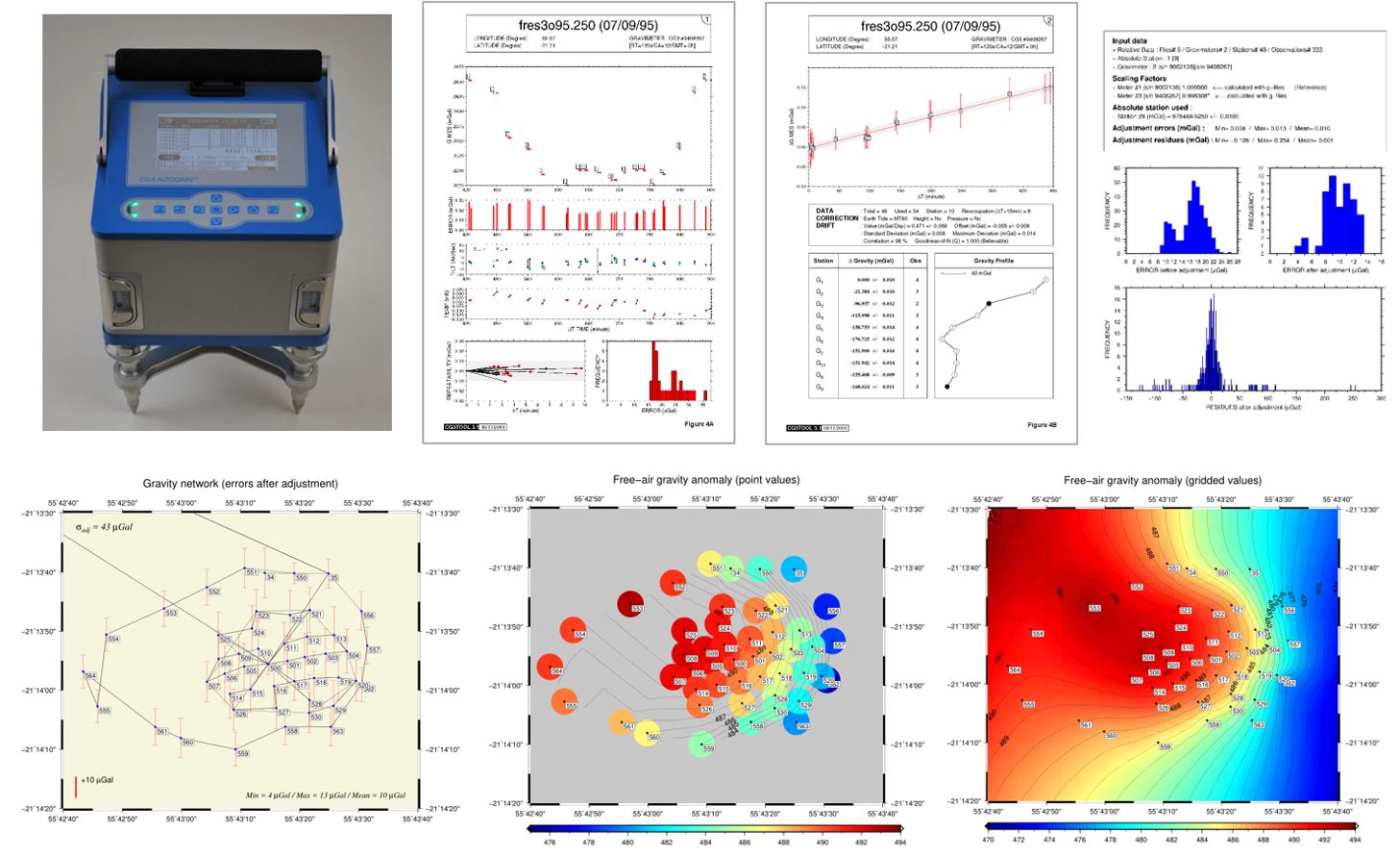
Authors: Germinal Gabalda, Sylvain Bonvalot (GET/BGI, Toulouse, France)
Technical notice : English / French / Spanish
Plateforms / OS: Windows / Linux
How to cite :
G. Gabalda and S. Bonvalot (2022). CG6TOOL: An interactive computer program to process Scintrex CG6 gravity data. Bureau Gravimetrique International. BGI Software. https://doi.org/10.18168/bgi.21
MGL_QuickView : Micro-g LaCoste “g” files quick view
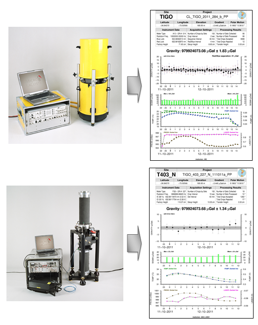
Summary : MGL_QuickView is a freely distributed stand-alone JAVA / Linux application enabling quick view of FG5 or A10 absolute gravity data acquisition results acquired through the MGL (Micro-g LaCoste) “g” software ( http://www.microglacoste.com). This application has been developed at Institut de Recherche pour le Développement (IRD) and BGI for facilitating the analysis and validation of absolute gravity data.
MGL_QuickView reads the standard MGL “g”output Ascii files (project, set and drop files) and uses the standard graphical and mathematical Generic Mapping Tools (GMT) free library to generate a PostScript© plot file displaying in a synthetic way the main information related to the data acquisition. The information displayed from the original MGL project file on the results and the parameters of the data acquisition contains:
- General information on site and project (site and project name, geographic coordinates, elevation, local gravity gradient and polar motion parameters corresponding to the data acquisition period)
- Instrument data parameters (meter type and serial number, Rubidium frequency, factory height)
- Acquisition setting parameters (number of drops per set, Drop and sequence intervals, Instrumental setup height)
- Processing results parameters (number of collected and processed sets, number of accepted and rejected drops, transfer height)
- Plots of time series of measurements (reduced absolute gravity values and their standard deviation) and environmental or instrumental monitored parameters (temperature and atmospheric pressure , Ion pump and laser voltages)
The graphical Java interface also enables updating the standard produced Postscript plot file with customized graphic parameters as well as selecting specific data sets.
Authors : Germinal Gabalda, Sylvain Bonvalot (GET/BGI, Toulouse, France)
Technical notice : English / French / Spanish
Plateforms / OS: Windows / Linux
How to cite :
G. Gabalda and S. Bonvalot (2022). MGL_Quickview of Micro-g LaCoste “g” files of absolute gravity measurements. Bureau Gravimetrique International. BGI Software. https://doi.org/10.18168/bgi.22
DIVA : Validation of terrestrial gravity surveys

Software used : CheckDataSet (BGI), DIVA (BGI), OasisMontaj / GEOSOFT ™
Not distributed