
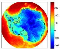
Antarctica crustal thickness model (Llubes et al. 2018)
We present a global map of Antarctic crustal thickness computed from space gravity observations as presented in Llubes et al. (2018). The crustal thickness model is provided in a grid Llubes 2018 Antarctica Crustal thickness.


Please, read the following document concerning grids format readme.
Other grids provided are:
Terrain gravity effects of ice, sea and surface rock derived from BEDMAP products (Fretwell et al. 2013).
Grids are available at resolutions of 5km Llubes 2018 Antarctica Terrain gravity effect and GOCE resolution 77km Llubes 18 Antarctica Terrain gravity effects 77 km
Bouguer anomalies estimated using free air anomalies of DIR5 gravity model (Bruinsma et al. 2014) Llubes 18 Antarctica Bouguer Anomalies.
Contact: lucia.seoane@get.omp.eu and muriel.llubes@get.omp.eu
References:
Bruinsma, S. L., Förste, C., Abrikosov, O., Lemoine, J.-M., Marty, J.-C., Mulet, S., Rio, M.-H. and Bonvalot, S.: ESA’s satellite-only gravity field model via the direct approach based on all GOCE data, Geophys. Res. Lett., 41(21), 7508–7514, doi:10.1002/2014GL062045, 2014.
Llubes, M., Seoane L., Bruinsma S. Remy F. (2018) . Crustal Thickness of Antarctica estimated using data from gravimetric satellites. Solid Earth, 9, 457-467, DOI: doi.org/10.5194/se-9-457-2018
Fretwell, P., et al. (2013). Bedmap2: improved ice bed, surface and thickness datasets for Antarctica, The Cryosphere, 7(1), 375–393, doi:10.5194/tc-7-375-2013.